From Wikipedia, the free encyclopedia
| Thames |
| River |
| The Thames in London |
| Country |  England England |
| Counties | Gloucestershire, Oxfordshire, Berkshire, Buckinghamshire, Essex, Kent |
|
| Cities | Oxford, Reading, Slough, London, Southend |
|
|
| Source | |
| - location | Kemble |
| - elevation | 110 m (361 ft) |
| Mouth | Thames Estuary, North Sea |
| - location | Southend-on-Sea, Essex, UK |
| - elevation | 0 m (0 ft) |
|
| Length | 346 km (215 mi) |
| Basin | 12,935 km² (4,994 sq mi) |
| Discharge | for London |
| - average | 65.8 m³/s (2,324 cu ft/s) |
| Discharge elsewhere (average) |
| - entering Oxford | 17.6 m³/s (622 cu ft/s) |
| - leaving Oxford | 24.8 m³/s (876 cu ft/s) |
| - Reading | 39.7 m³/s (1,402 cu ft/s) |
| - Windsor | 59.3 m³/s (2,094 cu ft/s) |
|
| |
The Thames (tɛmz (help·info)) is a major river flowing through southern England. While best known because its lower reaches flow through central London, the river flows through several other towns and cities, including Oxford, Reading and Windsor.
The river gives its name to the Thames Valley, a region of England centred around the river between Oxford and West London, and the Thames Gateway, the area centred around the tidal Thames and the Thames Estuary to the east of London.
[edit] Summary
The River Thames is the longest river entirely in England, rising officially at Thames Head in Gloucestershire, and flowing into the North Sea at the Thames Estuary. It has a special significance in flowing through London, the capital of the United Kingdom, although London only touches a short part of its course. The river is tidal in London with a rise and fall of 7 metres (23 ft) and becomes non-tidal at Teddington Lock. The catchment area covers a large part of South Eastern and Western England and the river is fed by over 20 tributaries. The river contains over 80 islands, and having both seawater and freshwater stretches supports a variety of wildlife.
The river has supported human activity from its source to its mouth for thousands of years providing habitation, water power, food and drink. It has also acted as a major highway both for international trade through the Port of London, and internally along its length and connecting to the British canal system. The river’s strategic position has seen it at the centre of many events and fashions in British history, earning it a description as “Liquid History”. It has been a physical and political boundary over the centuries and generated a range of river crossings. In more recent time the river has become a major leisure area supporting tourism and pleasure outings as well as the sports of rowing, sailing, skiffing, kayaking, and punting. The river has had a special appeal to writers, artists, musicians and film-makers and is well represented in the arts. It is still the subject of various debates about its course, nomenclature and history.
[edit] Physical and natural aspects
[edit] Course of the river

The monument at the official source of the Thames.

River Thames Flood Barrier
The Thames has a length of 215 miles (346 km). Its usually quoted source is at Thames Head (at grid reference ST980994), about a mile north of the village of Kemble and near the town of Cirencester, in the Cotswolds. However, Seven Springs near Cheltenham, where the river Churn rises, is also sometimes quoted as the Thames' source[1], as this location is furthest from the mouth both in distance along its course and as the crow flies and adds some 14 miles (22km) to the length. The springs at Seven Springs also flow throughout the year, while those at Thames Head are only seasonal.
The Thames flows through or alongside Ashton Keynes, Cricklade, Lechlade, Oxford, Abingdon, Wallingford, Goring-on-Thames, Reading, Henley-on-Thames, Marlow, Maidenhead, Windsor, Eton, Staines, Weybridge and Thames Ditton before entering the Greater London area. The present course is the result of several minor redirections of the main channel around Oxford, Abingdon and Maidenhead and more recently the creation of specific cuts to ease navigation.
From the outskirts of Greater London, the river passes Hampton Court, Kingston, Teddington, Twickenham, Richmond (with a famous view of the Thames from Richmond Hill), Syon House and Kew before flowing through central London. In central London, the river forms one of the principal axes of the city, from the Palace of Westminster to the Tower of London and was the southern boundary of the mediaeval city, with Southwark on the opposite bank.
Once past central London, the river passes between Greenwich and the Isle of Dogs, before flowing through the Thames Barrier, which protects central London from flooding in the event of storm surges. Below the barrier, the river passes Dartford, Tilbury and Gravesend before entering the Thames Estuary near Southend-on-Sea.
[edit] Catchment area and discharge
The river drains a catchment area of 4,994 square miles (12,934 km²) or 5,924 square miles (15,343 km²) if the River Medway is included as a tributary.[2]
[edit] The non-tidal section
-

The Jubilee River at Slough Weir
Brooks, canals and rivers, within an area of 3,841 square miles (9,948 km²), combine to form 38 main tributaries feeding the Thames between its source and Teddington Lock, the tidal limit. Before Teddington Lock was built in 1810-12, the river was tidal as far as Staines. The tributaries include the rivers Churn, Leach, Cole, Coln, Windrush, Evenlode, Cherwell, Ock, Thame, Pang, Kennet, Loddon, Colne, Wey and Mole. In addition there are many backwaters and distributaries and some man-made channels such as the Longford River.
More recently, an artificial secondary channel to the Thames, known as the Jubilee River, was built between Maidenhead and Windsor for flood relief, being completed in 2002.
More than half the rain that falls on this catchment is lost to evaporation and plant growth. The remainder provides the water resource that has to be shared between river flows, to support the natural environment, navigation and the community needs for water supplies to homes, industry and agriculture.
The non-tidal section of the river is managed by the Environment Agency which has the twin responsibilities of managing the flow of water to control flooding, and providing for navigation. The volume and speed of water down the river is managed by adjusting the gates at each of the weirs and at high water levels are usually dissipated over flood planes adjacent to the river. Occasionally flooding is unavoidable, and the Agency issues Flood Warnings. During heavy rainfall the Thames occasionally receives raw sewage discharge due to sanitary sewer overflow.
[edit] The tidal section
-

London Stone at Staines, built in 1285 marked the tidal limit of the Thames and the
City of London's jurisdiction

The lower course of the Thames in 1840
Below Teddington Lock (about 55 miles/89 kilometres upstream of the Thames Estuary) the river is subject to tidal activity from the North Sea. Before the lock was installed the river was tidal as far as Staines. London, capital of Roman Britain was established on two hills, now known as Cornhill and Ludgate Hill. These provided a firm base for a trading centre at the lowest possible point on the Thames.[3] A river crossing was built at the site of London Bridge. London Bridge is now used as the basis for published tide tables giving the times of high tide. High tide reaches Putney about 30 minutes later than London Bridge, and Teddington about an hour later. The tidal stretch of the river is known as "the Tideway".
The principal tributaries on the Tideway include the rivers Brent, Wandle, Effra, Westbourne, Fleet, Ravensbourne (the final part of which is called Deptford Creek), Lea, Roding, Darent and Ingrebourne. At London, the water is slightly brackish with sea salt, being a mix of sea and fresh water.
This part of the river is managed by the Port of London Authority. The flood threat here comes from high tides and strong winds from the North Sea, and the Thames Barrier was built in the 1980’s to protect London from this risk.
[edit] Islands
-
The river Thames contains over 80 islands ranging from the large esturial marshlands of the Isle of Sheppey, Isle of Grain and Canvey Island to small tree covered islets like Rose Isle, Oxfordshire and Headpile Eyot Berkshire. Some of the largest inland islands - Formosa Island near Cookham and Andersey Island at Abingdon - were created naturally when the course of the river divided into separate streams, while Desborough Island, Ham Island at Old Windsor and Penton Hook Island were artificially created by lock cuts and navigation channels. Chiswick Eyot is a familiar landmark on the Boat Race course, while Glover's Island forms the centrepiece of the spectacular view from Richmond Hill. Islands with a historical interest are Magna Carta Island at Runnymede, Fry's Island at Reading and Pharaoh's Island near Shepperton. In more recent times Platts Eyot at Hampton was the place where MTBs were built, Tagg's Island near Molesey was associated with the impresario Fred Karno, and Eel Pie Island at Twickenham was the birthplace of the South East’s R&B music scene.
[edit] Geological history
The River Thames can first be identified as a discrete drainage line as early as 58 million years ago, in the late Palaeocene Period Thanetian Stage.[4] Until around half a million years ago, the Thames flowed on its existing course through what is now Oxfordshire, before turning to the north east through Hertfordshire and East Anglia and reaching the North Sea near Ipswich. At this time the river system headwaters lay in the English West Midlands and may, at times, have received drainage from the North Wales Berwyn Mountains. Arrival of an ice sheet in the Quaternary Ice Age, about 450,000 years ago, dammed the river in Hertfordshire and caused it to be diverted onto its present course through London. This created a new river route aligned through Berkshire and on into London after which the river rejoined its original course in southern Essex, near the present River Blackwater estuary. Here it entered a substantial freshwater lake in the southern North Sea basin. The overspill of this lake caused the formation of the Dover Straits or Pas-de-Calais gap between Britain and France. Subsequent development led to the continuation of the course which the river follows at the present day.[5]
At the height of the last ice age around 12000 years ago, Britain was connected to mainland Europe via a large expanse of land known as Doggerland in the southern North Sea basin. At this time, the Thames' course did not continue to Doggerland, but was aligned southwards from the eastern Essex coast where it met the Rhine, the Meuse and the Scheldt[5] flowing from what are now The Netherlands and Belgium. These rivers formed a single river—the Channel River (Fleuve Manche)—that passed through the Dover Strait and drained into the Atlantic Ocean in the western English Channel.
[edit] Wildlife
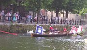
Swan Upping -
skiffs surround the swans
Various species of bird feed off the river or nest on it, some being found both at sea and inland. These include Cormorant, Black-headed Gull, and Herring Gull. The Swan is a familiar sight on the river but the Black Swan is more rare. The annual ceremony of Swan upping is an old tradition of counting stocks. Geese that can be seen include Canada Geese, Egyptian Geese, and Bar-headed Geese, and familiar ducks include the Mallard, Mandarin Duck, and Wood Duck. Other water birds to be found on the Thames include the Great Crested Grebe, Coot, Moorhen, Heron, and Kingfisher. In addition there are many types of British birds that live alongside the river, although they are not specific to the river habitat.
The Thames contains both seawater and freshwater, thus providing support for seawater and freshwater fish. The salmon, which inhabits both environments has been reintroduced, and succession of fish ladders built into weirs to allow them to travel upstream. The eel is a particularly associated with the Thames and there were formerly many eel traps designed to catch them. Some of the freshwater fish to be found in the Thames and its tributaries include brown trout, chub, dace, roach, barbel, perch, pike, bleak, and flounder. Colonies of short-snouted seahorses have also recently been discovered in the river.[6]
In addition the Thames is host to some invasive crustaceans including Signal crayfish and Chinese Mitten Crab.
On 20 January 2006 a northern 16-18 ft (5 m) bottle-nosed whale was spotted in the Thames and was seen as far upstream as Chelsea. This is extremely unusual because this type of whale is generally found in deep sea waters. Crowds gathered along the riverbanks to witness the extraordinary spectacle. But it soon became clear there was cause for concern, as the animal came within yards of the banks, almost beaching, and crashed into an empty boat causing slight bleeding. Approximately 12 hours later, the whale was believed to be seen again near Greenwich, possibly heading back to sea. There was a rescue attempt lasting several hours, but it eventually died on a barge. See River Thames whale.[7]
[edit] Human aspects
The River Thames has served several roles in human history, being an economic resource, a water highway, a boundary, a fresh water source, also a source of food and more recently a leisure facility.
[edit] Human history

The Tower, with Tower Bridge built 800 years later

An engraving by Claes Van Visscher showing Old London Bridge in 1616, with
Southwark Cathedral in the foreground

Wallingford Bridge and St Peter's Church

The Thames as it flows through London, with the
Isle of Dogs in the centre.
There is evidence of human habitation living off the river along its length dating back to Neolithic times.[8] The British Museum has a decorated bowl (3300-2700 BC), found in the River at Hedsor, Buckinghamshire and a considerable amount of material was discovered during the excavations of Dorney Lake.[9] A number of Bronze Age sites and artifacts have been discovered along the banks of the River including settlements at Lechlade, Cookham and Sunbury-on-Thames. Some of the earliest written accounts of the Thames occur in Julius Caesar’s account of his second expedition to Britain in 54BC[10] when the Thames presented a major obstacle and he encountered the Iron Age Belgic tribes the Catuvellauni, and the Atrebates along the river.
Under the Emperor Claudius in AD 43, the Romans occupied England and recognising the River's strategic and economic importance, built fortifications along the Thames valley including a major camp at Dorchester. Two hills, now known as Cornhill and Ludgate Hill, provided a firm base for a trading centre at the lowest possible point on the Thames called Londinium where a bridge was built. The next Roman bridge upstream was at Staines (Pontes) to which point boats could be swept up on the rising tide with no need for wind or muscle power. Many of the Thames’ riverside settlements trace their origins back to very early roots and the suffix - “ing” in towns such as Goring and Reading, Berkshire owe their origins to the Saxons. Recent research suggests that these peoples preceded the Romans rather than replaced them.[11] The river’s long tradition of farming, fishing, milling and trade with other nations started with these peoples and has continued to the present day. Competition for the use of the river created the centuries-old conflict between those who wanted to dam the river to build millraces and fish traps and those who wanted to travel and carry goods on it. Economic prosperity and the foundation of wealthy monasteries by the Anglo-Saxons attracted unwelcome visitors and by around AD 870 the Vikings were sweeping up the Thames on the tide and creating havoc as in their destruction of Chertsey Abbey.
Once King William had won total control of the strategic Thames Valley he went on to invade the rest of England. He had many castles built, including those at Wallingford, Rochester, Windsor and most importantly the Tower of London. Many details of Thames activity are recorded in the Domesday book. The following centuries saw the conflict between King and Barons coming to a head in AD 1215 when King John was forced to sign the Magna Carta on an island in the Thames at Runnymede. This granted them among a host of other things under Clause 23 the right of Navigation. Another major consequence of John’s reign was the completion of the multi-piered London Bridge which acted as a barricade and barrage on the river, affecting the tidal flow upstream and increasing the likelihood of freezing over. In Tudor and Stuart times the Kings and Queens loved the river and built magnificent riverside palaces at Hampton Court, Kew, Richmond on Thames, Whitehall and Greenwich.
The 16th and 17th Centuries saw the City of London grow with the expansion of world trade. The wharves of the Pool of London were thick with sea-going vessels while naval dockyards were built at Deptford. The Dutch navy even entered the Thames in 1667 in the raid on the Medway.
A cold series of winters led to the Thames freezing over above London Bridge, and this led to the first Frost Fair in 1607, complete with a tent city set up on the river itself and offering a number of amusements, including ice bowling. In good conditions barges travelled daily from Oxford to London carrying timber and wool, foodstuffs and livestock, battling with the millers on the way. The stone from the Cotswolds used to rebuild St Paul’s Cathedral after the Great Fire in 1666 was brought all the way down from Radcot. The Thames provided the major highway between London and Westminster in the 16th and 17th centuries and the clannish guild of watermen ferried Londoners from landing to landing and tolerated no outside interference. In AD 1715 Thomas Doggett was so grateful to a local waterman for his efforts to ferry him home pulling against the tide, that he set up a rowing race for professional watermen known as “Doggett's Coat and Badge”.
By the 18th century, the Thames was one of the world's busiest waterways, as London became the centre of the vast, mercantile British Empire and progressively over the next century the docks expanded in the Isle of Dogs and beyond.. Efforts were made to resolve the navigation conflicts up stream by building locks along the Thames. After temperatures began to rise again, starting in 1814, the river stopped freezing over completely.[12] The building of a new London Bridge in 1825 with fewer pillars than the old, allowed the river to flow more freely and reduced the likelihood of freezing over in cold winters.[13]
The Victorian era was an era of imaginative engineering. In the 'Great Stink' of 1858, pollution in the river reached such proportions that sittings at the House of Commons at Westminster had to be abandoned. A concerted effort to contain the city's sewage, by constructing massive sewers on the north and south river embankments followed, under the supervision of engineer Joseph Bazalgette. Meanwhile, similar huge undertakings took place to ensure water supply, with the building of reservoirs and pumping stations on the river to the west of London. The embankments in London house the water supply to homes, plus the sewers, and protect London from flood. The coming of rail added both spectacular and ugly railway bridges to fine range of earlier road bridges but reduced commercial activity on the river. However sporting and leisure use increased with the establishment of regattas like Henley and The Boat Race. On 3 September 1878, one of the worst river disasters in England took place, when the crowded pleasure boat Princess Alice collided with the Bywell Castle, killing over 640 people.
The growth of road transport and the decline of the Empire, in the years following 1914, reduced the economic prominence of the river. During World War II the protection of the Thames was crucial to the defence of the country. Defences included the Maunsell forts in the estuary and barrage balloons to cope with the threat of German bombers using the distinctive shape of the river to navigate during The Blitz. Although the Port of London remains one of the UK's three main ports, most trade has moved downstream from central London. The decline of manufacturing industry and improved sewage treatment have led to a massive clean-up since the filthy days of the late 19th and early- to mid-20th centuries, and aquatic life has returned to its formerly 'dead' waters. Alongside the river runs the Thames Path, providing a route for walkers and cyclists.
In the early 1980s a massive flood-control device, the Thames Barrier, was opened. It is closed several times a year to prevent water damage to London's low-lying areas upstream (as in the 1928 Thames flood for example). In the late 1990s, the 7-mile (11 km) long Jubilee River was built, which acts as a flood channel for the Thames around Maidenhead and Windsor.[14]
[edit] Origin of the name
The Thames, from Middle English Temese, is derived from the Celtic name for the river, Tamesas (from *tamēssa)[15], recorded in Latin as Tamesis and underlying modern Welsh Tafwys "Thames". The name probably meant "dark" and can be compared to other cognates such as Irish teimheal and Welsh tywyll "darkness" (PC *temeslos) and Middle Irish teimen "dark gray"[15], though Richard Coates[16] mentions other theories: Kenneth Jackson's[17] that it is non Indo-European (and of unknown meaning), and Peter Kitson's[18] that it is IE but pre-Celtic, and has a name indicating muddiness from a root *tã-, 'melt'.
The river's name has always been pronounced with a simple t; the Middle English spelling was typically Temese and Celtic Tamesis. The th lends an air of Greek to the name and was added during the Renaissance, possibly to reflect or support a belief that the name was derived from River Thyamis in the Epirus region of Greece, whence early Celtic tribes were erroneously thought to have migrated.
Indirect evidence for the antiquity of the name 'Thames' is provided by a Roman potsherd found at Oxford, bearing the inscription Tamesubugus fecit (Tamesubugus made this). It is believed that Tamesubugus's name was derived from that of the river.[19]
The Thames through Oxford is often given the name the River Isis, although historically, and especially in Victorian times, gazetteers and cartographers insisted that the entire river was correctly named the River Isis from its source until Dorchester-on-Thames. Only at this point, where the river meets the River Thame and becomes the "Thame-isis" (subsequently abbreviated to Thames) should it be so-called; Ordnance Survey maps still label the Thames as "River Thames or Isis" until Dorchester. However since the early 20th century, this distinction has been lost in common usage outside Oxford, and some historians suggest the name Isis—although possibly named after the Egyptian goddess of that name—is nothing more than a contraction of Tamesis, the Latin (or pre-Roman Celtic) name for the Thames.
Richard Coates suggests that while the river was as a whole called the Thames, part of it, where it was too wide to ford, was called *(p)lowonida. This gave the name to a settlement on its banks, which became known as Londinium, from the Indo-European roots *pleu- "flow" and *-nedi "river" meaning something like the flowing river or the wide flowing unfordable river).[16]
For merchant seamen, the Thames has long been just 'The London River'. Londoners often refer to it simply as 'the river', in expressions such as 'south of the river'.[20]


